Following publication of the landmark book Les Minquiers – A Natural History Birds On The Edge asked one of the authors, Paul Chambers, to discuss the book and these remarkable but poorly known islands.
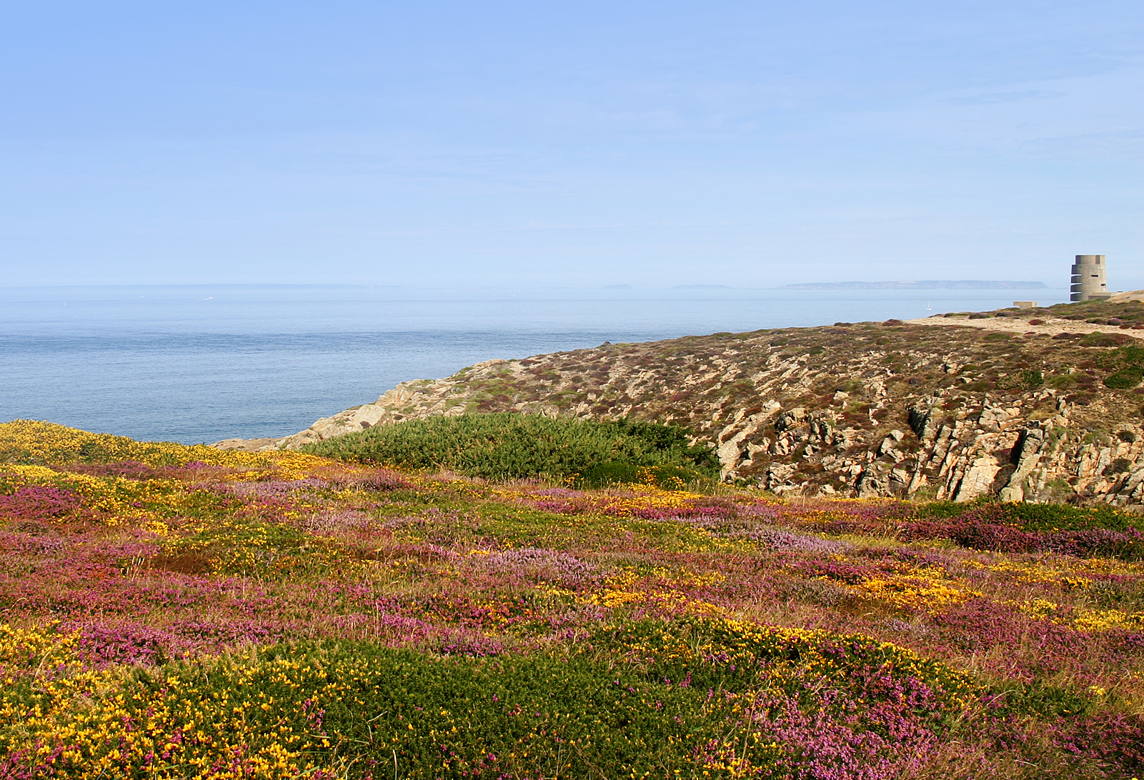
Situated just 12 miles south of St Helier, the tangle of rocks, reefs and sandbanks that form Les Minquiers is a world entirely removed from the bustle and traffic of Jersey life.
At 300 km2 the Minquiers’ plateau is larger than most British cities and yet at high tide only 0.002 km2 remains above the sea. Six hours later (and drop in sea level of up to 13 metres) and the area of exposed seashore expands by some 10,000 per cent to 20 km2. The reef holds around 20,000 individual rocks the oldest of which are at least 640 million years old. The one vegetated island, Maîtresse Île, has a rich prehistoric archaeology which suggests it has been regularly used by humans over the past 4,500 years.
This wonder of the natural world is sat on Jersey’s doorstep and yet until recently very little was known about the history or natural history of Les Minquiers. ‘There is perhaps no area of comparable extent in the British Isles about which so little is known,’ wrote the celebrated geologist Dr Arthur Mourant in 1977. This remained true until 2012 when a small team from Jersey’s Société Jersiaise set out to document the reef’s marine and terrestrial biology.
Following the recent publication of the team’s landmark book on the history and natural history of Les Minquiers (see book here) we are pleased to present an overview of the current ecological health of Les Minquiers. This has been adapted from the ‘Summary and Conclusions’ chapter in the book.
Introduction

Les Minquiers. July 2016. Photo by Glyn Young
In 1998 the Jersey in the New Millennium government consultation document stated that Les Écréhous and Les Minquiers ‘may very well warrant SSI [Site of Special Interest] designation and even international recognition but there is an urgent need to recognise their unique character and the ecology/landscape/leisure use linkages in a “national park” style designation akin to that given to Les Mielles. The increase in leisure boating activity and the number of marinas on the adjacent French coast will subject these reefs to increasing people pressure with obvious knock-on ecological impacts’.
Since this was written all of Jersey’s offshore reefs have been designated as Ramsar (Wetlands of International Importance) areas and the terrestrial areas included within the Jersey National Park. Maîtresse Île is scheduled to become a Site of Special Interest (SSI) and has been subject to various management plans, laws, policies and multilateral environmental agreements.
This has drawn attention to the importance of the offshore reefs and yet, until recently, there remained a general lack of appreciation of their histories and natural histories, and an absence of coordinated study, management and monitoring. It was this knowledge gap that inspired a small team of amateur and professional naturalists to spend four years studying all aspects of Les Minquiers, from its history, archaeology and geology to its animal and plant life. Their results are published in the book, already described as ‘an achievement on a global scale’ by The Sunday Times environment correspondent (and author of End of the Line) Charles Clover.

Les Minquiers. April 2011. Photo by Glyn Young
Aside from providing a comprehensive overview of every aspect of Les Minquiers, the project’s results provide much of the basic information that is needed by local, national and perhaps international authorities to make decisions regarding the reef’s present-day management, as well as to develop strategies to safeguard its future.
Presented below is a summary of those results and conclusions that most concern the general environmental and ecological health of Les Minquiers, especially those which might have some relevance to the reef’s future management.
These should not be taken as an exhaustive summary of all the project’s results as much other information is provided in the book and a reading of the relevant chapters is recommended. Regardless of how the information derived from this project is used in the future, the authors would like to think that their work does fulfil the ‘urgent need to recognise the unique character’ of Les Minquiers, as requested by the States of Jersey in 1998.
A summary of physical and environmental change
Presented below is a summary of key facts and conclusions relating to the current and historical environmental status of Les Minquiers. This includes aspects of the reef’s archaeology and oceanography but does not include summaries of information relating to the human and geological history of the reef unless it touches on ecological and environmental matters.
Physical Geography, Oceanography and Sedimentology
The general topography of Les Minquiers has probably changed little since the post-glacial sea level stabilised around 2,000 to 4,000 years ago. Much of the plateau is made of hard igneous rock about ten per cent of which is exposed at low water. There has been little opportunity for human activity to destroy or alter the bedrock and so many parts of the reef will present the same profile now as they did when the first Bronze Age hunters travelled to the reef in search of seals.
The main exception to this is Maîtresse Île and several nearby rocks whose physical profile has changed considerably following quarrying in the early nineteenth century. The removal of rock from the north-west and south-east of the island may have accelerated soil erosion by allowing breaking waves to access the area west of the huts. It is probable that some soil erosion had occurred prior to this but quarrying may have accelerated the process.
A second noticeable change in topography concerns the reef’s many sandbanks which build up against rocks or form in the lee of obstacles within tidal currents. An obvious example is the large sandbank known as Le Gris Banc which, since the time of the first hydrographic surveys, has moved steadily eastwards into an adjacent channel. This movement accelerated in the 1990s entirely closing what was once a navigable gap of around 300 metres. Other less strategic sandbanks, such as Le Banc du Turbot, may also have changed shape in recent decades. Although visually remarkable and a nuisance to boaters and chart makers, sandbank movement is probably part of a natural cycle of accumulation and erosion within the reef.

Le Gris Banc a sandbank at Les Minquiers which has moved 300 metres during the past decade. From Les Minquiers – A Natural History
Maîtresse Île
The small terrestrial area of Maîtresse Île has probably seen the greatest change of any place on Les Minquiers. Prior to the nineteenth century Maîtresse Île was a remote, largely untouched, vegetated island with no freshwater which was irregularly visited by fishermen. Then came the quarrymen and more organised fishing from La Rocque Harbour so that by the mid-nineteenth century around 18 stone buildings had been built which were permanently inhabited during the spring and summer months. It is probable that the fishermen managed the island’s vegetation (especially tree mallow) creating habitats for specialist coastal plants such as grasses. Throughout this time soil erosion continued to operate on the western and north-eastern edges of the island.

Maitresse Ile. April 2011. Photo by Glyn Young
Plant life
Following World War II the huts were abandoned, allowing plants and birds to take over. Renovation of the derelict buildings began in the 1970s and, by the 1980s, had led to a new phase of development and occupation by Jersey families. In 2016 just two hut sites remain undeveloped. As huts have been renovated and visitor numbers have increased, so the biology and ecology of Maîtresse Île has gradually changed. This was accelerated by the application of weed killer across the island in 1973 which removed an estimated 99% of all plant life. Erosion was enhanced immediately following this event leading to considerable soil loss.
. April 2011. Photo by Glyn Young")
Tree mallow (with mist net). April 2011. Photo by Glyn Young
Over the past century a total of 26 plant species have at some point been recorded from Maîtresse Île. The most species observed during an individual survey was 16 in 1973, immediately after the weed killer incident when, ironically, opportunistic weeds temporarily appeared. Currently there are eight known species with those plants that have disappeared during the past century mostly being grasses and short species such as thrift. Some of these (including thrift) may have been permanently removed by the weed killer incident while others were possibly crowded out by the tree mallow which currently dominates the island.
It is possible that tree mallow is naturally pervasive on Maîtresse Île and that, left to its own devices, this is the species that will proliferate and dominate. Other historically recorded species, such as grasses and thrift, may have been present only as long as the fishermen were resident and regularly clearing the tree mallow.
Aside from aesthetics, the most important roles of vegetation are to prevent soil erosion and provide food and shelter for wildlife. This is especially true for the island’s bird life with almost all the 92 recorded breeding and migratory species being dependent on the presence of tree mallow.
The destruction of vegetation exposes soil to the effects of waves, wind and rain, causing it to erode rapidly. Since 1928 Maîtresse Île has lost an estimated 50 per cent of its soil cover and it is soil erosion, above all else, that presents the greatest environmental threat to the island’s ecology. Soil provides an anchor for vegetation which is in turn needed by birds and invertebrate animals. Soil also supports hut foundations and contains archaeological material.
Although the issue of soil erosion has been raised several times by archaeologists, little has been done to address it. This should form a central part of any future management plans for Maîtresse Île, especially with regard to the way in which visitors and residents use the island. Without soil, Maîtresse Île will lose its wildlife, its infrastructure and its archaeology. Without soil, the central part of the island will be around a metre lower in height which will permit storm waves to sweep up from the south and east and cross the spine of the island.
Only the high points around the flagpole, Le Gabé and to the west of the toilet will be significantly above the high water mark. In such circumstances the huts and any terrestrial species are unlikely to survive, leaving Maîtresse Île a largely barren rock that, like La Grande Maison, would support only nesting birds, maritime algae and some lichens.
Nesting birds
Another notable biological change to have occurred in recent decades is in the use of Maîtresse Île by nesting birds. The discovery of seabird bones from the Bronze Age suggests that the island has been used as a nesting place for thousands of years. It is unlikely that seabirds would have nested successfully when fishermen were in residence as the nests would probably have been raided or scattered. After World War II birds did nest successfully as the ruined huts provided shelter for shags, gulls and other seabirds. Since renovation of the huts began in the 1970s, there has been a decrease in the number of species nesting so that currently it is only gull species which nest in any number on the rocky areas to the west and north of the huts although, in July and August 2015, a large number of Terns nested on the north of the island for the first time in living memory.

Les Maisons. Photo by Mick Dryden
Disturbance
In recent years weather, inadvertent disturbance and deliberate damage to nests has led to some poor breeding seasons on Maîtresse Île. For example, in 2014 all the gulls’ nests were deliberately destroyed early in the season leading to a disastrous breeding year for the birds. Additional monitoring of when, where and which species are nesting on the island might allow for a more targeted management during the nesting season. A second nesting site exists around the base of the beacon at La Grande Maison which seems to receive little human interference.
There have been many other events and incidents that have affected the ecology of Maîtresse Île in some way. Most of these result from individual acts of ignorance, such as clearing vegetation for camping or picnics, placing heavy machinery on the island and lighting barbecues on bare soil or next to huts. Other actions derive from ignorance or wanton destruction of property and the dumping of litter and chemicals are more deliberate acts.
An increased awareness of the fragility of Maîtresse Île’s ecology amongst visitors and residents will go some way to resolving these problems. Signs, websites and literature (such as posters and leaflets at marinas) should promote a greater understanding of Maîtresse Île and its ecology. There have also been issues around repairs and renovations on the island and it is recommended that future projects (whether by Jersey’s authorities or individuals) are made to adhere to tight management plans which avoid the risk of soil erosion, habitat destruction and pollution.
Climate change
One final and probably unavoidable issue facing Maîtresse Île is that of climate change and rising sea levels. Many different models and claims are made about the cause and visible effects of climate change but evidence does suggest that the global climate is undergoing a warming phase and that the sea level is rising. For low-lying islands and reefs this is not good news, as even small sea level rises risk increased erosion and marine inundation. This may be compounded by a predicted increase in the number and severity of storm surges as the warmer seas create and empower low pressure systems.

Maitresse Ile. April 2011. Photo by Glyn Young
Between October 2013 and March 2014 the coast of Europe was hit by a series of spectacular storms that rolled in off the Atlantic swamping and damaging coastlines along the English Channel. On Maîtresse Île these storms removed soil from the west of the island, damaged two of the seawalls and undermined the concrete area at the top of the slipway. Similarly, a storm surge in February 2008 damaged a wall and shifted large boulders across the slipway. As the sea level rises, so the destructive potential of waves will move higher up the island placing pressure on the sea defences and further increase the action of soil erosion. This issue is being addressed for Jersey’s sea defences and needs to be addressed for Maîtresse Île too.
The results from this project suggest that Maîtresse Île is facing several immediate threats, the most serious of which are issues relating to soil erosion, habitat/species loss and storm damage. These, and other threats, are best addressed through coherent management and monitoring of the island, investment in infrastructure maintenance, the cooperation of its principal users and raising awareness for visitors and potential visitors.

Maitresse Ile at Les Minquiers: soil erosion means it gets smaller every year. Les Minquiers – A Natural History